Flooding & Subsidence
Below are resources for teaching about surface water (and when we get too much of it) and ground water (and when we use too much of it).
Overview
SUBSIDENCE: HOUSTON IS SINKING
In 1975, the Texas Legislature created the Harris-Galveston Subsidence District “to provide for the regulation of groundwater withdrawal for the purpose of preventing land subsidence.” The area is sinking due to groundwater withdrawal from underground aquifers. The layers of clay compact, and because of our proximity to the ocean, this sinking land is inundated with water.
The Brownwood Subdivision in the City of Baytown is now mostly underwater, and was turned into a nature area (with fishing piers) by the city. Should subsidence continue, more residential areas may be underwater. Ecosystems will change, too, depending upon the amount of fresh or saltwater intrusion.
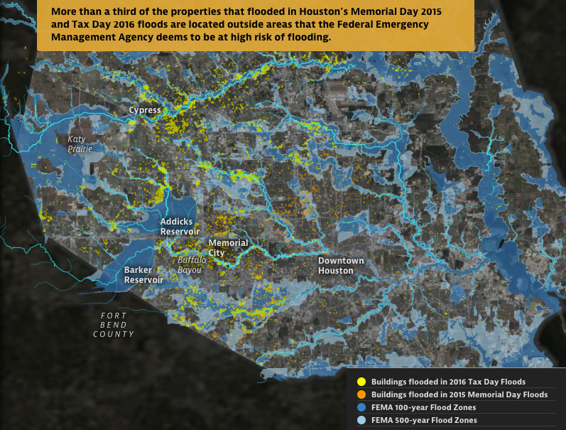
FLOODING: HOUSTON IS DROWNING
Jim Blackburn says, “Here on the Texas coast, we get intense rainfall events that cause flooding along our bayous, rivers, creeks, and roadways, and occasionally we get hurricanes with surge, which is water that is pushed ashore by the storm’s rotating winds and forward movement. Either storm event can affect the security of your property, your family, and yourself.”
From Harris County Flood Control, “It should be noted that a total of 1 trillion gallons of water fell across Harris County over a four-day period during Hurricane Harvey. This amount of water would cover Harris County’s 1,800 square miles with an average of 33 inches of water. More than two dozen rainfall gauges registered seven-day readings topping 40 inches. Harris County generally receives an annual rainfall of about 50 inches per year. This unprecedented storm event impacted the residents of each of Harris County’s 22 watersheds, and it is estimated that more than 120,000 structures were flooded in Harris County, alone.”
Local Resources
Texas Weather Service daily data
Harris-Galveston Subsidence District, including great education videos on their YouTube channel
Harris County Flood Control District, with watershed maps and data
Activities/Lessons
Middle/High School
Know your Watershed interactive maps and virtual tour of local watersheds
Texas Aquatic Science is a comprehensive aquatic science curriculum, from molecules to ecosystems, and headwaters to ocean, for middle school and high school students; it includes an online student textbook, a teacher guide, specially produced videos, and supplementary materials.
Use the new floodplain mapping tool from Harris County Flood Control to incorporate maps and data.
National Weather Service has activities about weather events. Create a free account to access.
Listen to the podcast, “The Next Houston Hurricane May be Worse than Harvey - Let’s Get Ready.”
Lesson from Teach Engineering: Above-Ground Storage Tanks in the Houston Ship Channel, Physics/Fluid Mechanics/Engineering. Students are provided an introduction to storage tanks, Archimedes’ principle and Pascal’s law, and are tasked with designing tanks that won’t fail in a massive storm.
Lessons from Harris-Galveston Subsidence District with Storymap and Student Tasks; Grade 8 - 12, Topics: water use/subsidence and STEM
Virtual Subsidence Tour from Harris-Galveston Subsidence District with Storymap
ELEMENTARY SCHOOL
National Weather Service has activities about weather. Create a free account to access.
These are local teacher’s lesson plans:
Problems from and Solutions to Flooding in a 5E lesson format. PDF Version or Word Version - ELAR or Science, Grades 3&4, TEKS: 3.7& 4.2
Dangers of Flood Waters in a 5E lesson format. PDF Version or Word Version - ELAR, Grade: 4, TEKS: 7
Students model flooding in a 5E lesson format. PDF Version or Word Version - Science, Grade: 4, TEKS: 7
Maps - Click here to view all maps
Videos
Hurricane Harvey's rainfall broke continental U.S. records. Here's how cities like Houston can better prepare.
Brownwood, Baytown, Texas was a neighborhood that subsided to the point of being uninhabitable.
Banner image from ABC13/Instagram.


